P.O Box 61, Mpigi| Tel :+256 772 440682 | E-mail: [email protected]

Overview
Gomba District is bordered by Mubende District to the west and north, Mityana District to the northeast and Butambala District to the east. Kalungu District, Bukomansimbi District and Sembabule District lie to the south of Gomba District. Kanoni, where the district headquarters are located, lies approximately 97 kilometres (60 mi), by road, southwest of Kampala, the capital of Uganda and the largest city in that country. This location is approximately 60 kilometres (37 mi), by road, west of Mpigi, the nearest large metropolitan area.[2] The coordinates of the district are:00 11N, 31 55E. (Latitude:0.1750; Longitude:31.9100).
Overview
Gomba District was created in 2010 by Act of Parliament, when Mpigi District was split into three: (a) Gomba District, (b) Butambala District and (c) Mpigi District. The town of Kanoni was selected to be the district headquarters. The district became operational on 1 July 2010. Generally, Gomba District is a rural district which receives lower precipitation than the districts of Butambala and Mpigi. Livestock farming is a major economic activity in the district supplemented with subsistence agriculture.[3]
Population
In 1991, the national population census estimated the district population at about 170,000.
Gomba District covers an area of approximately 1,851 square kilometers and is bordered by Mityana District to the north, Butambala District to the east, Sembabule District to the south, and Mubende District to the west.
The district is primarily rural and is characterized by a diverse landscape, including rolling hills, farmlands, forests, and wetlands. Agriculture is the main economic activity in Gomba, with crops such as coffee, bananas, maize, and beans being the primary agricultural products.
Gomba District is also known for its cultural heritage and historical significance. It is part of the Buganda Kingdom, which is one of the oldest and most powerful traditional kingdoms in Uganda. The kingdom plays a significant role in the cultural and social life of the people in the district.
Profile of the Local Government
Location: Gomba District is located in the Central Region of Uganda. It is bordered by Mityana District to the north, Butambala District to the east, Sembabule District to the south, and Mubende District to the west.
Administrative Center: The district's administrative centre is the town of Kanoni.
Leadership: The local government of Gomba District is headed by the District Chairperson, who is elected by the residents in the district. The district is further divided into sub-counties, town councils, and parishes, each with its local leadership structures.
Political Representation: Gomba District is represented in the Ugandan Parliament by Members of Parliament (MPs) elected to represent the various constituencies within the district.
Economy: Gomba District's economy is primarily based on agriculture. The majority of the population engages in subsistence farming, cultivating crops like coffee, bananas, maize, beans, and other food crops.
Infrastructure: The district's infrastructure includes roads, bridges, and other basic facilities necessary for transportation and connectivity.
Culture and Heritage : Gomba District, being part of the Buganda Kingdom, has a rich cultural heritage. Traditional customs and practices are still observed, and cultural events and festivals are an essential part of community life.
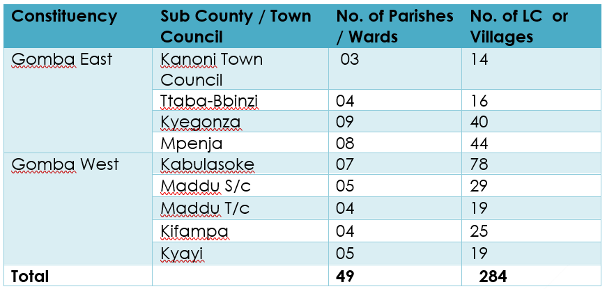
Administrative Units
Image: